
Deggendorf
94469 Deggendorf, Deutschland
Ruselabsatz | Hiking & Ski Trails
The Ruselabsatz is a mountain pass and also a functional excursion destination on the edge of the Bavarian Forest near Deggendorf. Official tourism sites describe the area as the starting point of the hiking center Rusel-Oberbreitenau; at the Ruselhaus, there is current information and maps, and summer and winter tours start from the parking lot at Ruselabsatz. Those who arrive here find no classic event location, but rather a landscape and movement space: hiking trails, winter hiking paths, cross-country skiing, viewpoints, mountain biking routes, and places to eat are closely situated together. This is exactly what makes Ruselabsatz so attractive for searches related to hiking, ski trails, parking, weather, and snow. The location above Deggendorf immediately gives the feeling of transitioning from the Danube plain into the forest and up into the heights. Even in the first few meters, it becomes clear why the place is interesting for day visitors, families, athletes, and those seeking peace. ([deggendorf.travel](https://deggendorf.travel/freizeit/wandern/zielwanderweg-ruselabsatz?utm_source=openai))
Hiking and Circular Trail at Ruselabsatz
The most important theme at Ruselabsatz is hiking. Official sites name the location as the starting point for the destination hiking trail Ruselabsatz; the tour is marked as circular route 4, about 5.3 kilometers long, takes approximately 2.5 hours, and overcomes around 312 meters of elevation. The path initially leads from the parking lot of the cross-country skiing and hiking center over forest roads as well as forest and meadow paths, crosses a feeder to the Goldsteig and the local GEHsundheitsweg, thus connecting several well-known routes. A particularly rewarding detour is to the Geßingerstein, from which a wide view opens over the Lallinger Winkel, the foothills, and the Danube plain; in good visibility, the view even extends to the Alps, and in föhn conditions, one can officially recognize the Hohensalzburg Fortress in the distance. Those who prefer a shorter route can use Ruselabsatz as a starting point for the surrounding circular and destination paths or as an entry into the hiking center Rusel-Oberbreitenau, which, according to the district, offers hiking fun on over 400 kilometers of trails. The mix of marked infrastructure, nature experience, and easily recognizable destinations explains why search queries like ruselabsatz hiking and ruselabsatz circular trail are among the strongest terms. ([deggendorf.travel](https://deggendorf.travel/freizeit/wandern/zielwanderweg-ruselabsatz?utm_source=openai))
In practice, the clarity of the paths at Ruselabsatz is a significant advantage. The region around Rusel, Hausstein, and Oberbreitenau is not only scenically appealing but also logically developed: path markings, feeders, and destination hiking trails complement each other, allowing you to plan both a leisurely round and a longer tour. The destination hiking trail Ruselabsatz is well-suited for those looking for a manageable yet not boring route. The combination of forest road, woodland path, and more open sections keeps the tour varied without becoming confusing. This is also a plus for families, as there are clear orientation points along the way, and the path can be easily thought out in stages. Those who want to seriously explore the region should also take time for the surroundings: Ruselabsatz is not only a starting point but part of a connected network of hiking destinations, viewpoints, and places to eat. This is precisely why terms like ruselabsatz deggendorf and ruselabsatz elevation often appear in searches, as the location itself is already an essential part of the experience. ([deggendorf.travel](https://deggendorf.travel/freizeit/wandern/zielwanderweg-ruselabsatz?utm_source=openai))
Parking, Access, and Costs at Ruselabsatz
For access and parking, Ruselabsatz is also well-equipped, even though it is not a parking lot in the strict sense, but an organized starting point in the hiking area. The district names the hiking parking lots at Ruselhaus on Ruselbergstraße or St 2135, at Ruselabsatz, in Rohrmünz, and in Unterbreitenau as ideal starting points for tours on the Rusel. It is important for on-site use that the Ruselhaus at the parking lot serves as an information point, thus acting not only as an orientation aid but also as a practical meeting point for maps, routes, and weather questions. In winter, the parking situation shifts somewhat: for the toboggan run on the side of the former mountain hotel Rusel, the parking lot there is available on weekends, while on other days, parking can be done at Ruselabsatz, from where the winter hiking path along the road is used; the parking lot at the golf course opposite is closed. This is valuable for hikers and winter guests because it allows for flexible planning of the journey. An official parking fee is not listed on the mentioned sites, so visitors are best advised to pay attention to the current signage and information on-site. Here, too, the search demand is logical: those entering ruselabsatz parking or ruselabsatz parking costs are usually not looking for extensive infrastructure, but a clear, reliable answer regarding practical accessibility. ([landkreis-deggendorf.de](https://www.landkreis-deggendorf.de/tourismus-kultur/freizeit-aktiv/wandern/wandern-auf-der-rusel/?utm_source=openai))
Additionally, Ruselabsatz is an important meeting point for sporting formats and guided tours. The district uses the south-side parking lot as a meeting point for hikes around the Königsstein, and at the Heimat Trails Trophy, Ruselabsatz has repeatedly been described as a prominent start and finish area. This shows that the place works not only for spontaneous day-trippers but also for organized leisure offerings. Those arriving by car benefit from the compact development: from the parking lot, it is only a few steps to the transition into the paths of the hiking center, to the entrances to the ski trails, or to the starting points for winter and snowshoe tours. Especially in winter, this proximity to the start is crucial, as one does not have to undertake long approaches first. Thus, a parking lot becomes a meaningful logistical hub for day trips. So, those searching for a combination of ruselabsatz deggendorf, ruselabsatz parking, and ruselabsatz weather are essentially planning an excursion that arrives comfortably and quickly leads into nature. ([landkreis-deggendorf.de](https://www.landkreis-deggendorf.de/aktuelles/aus-dem-landkreis/mit-der-rangerin-zum-koenigsstein/?utm_source=openai))
Cross-Country Skiing, Ski Trails, and Snow in the Rusel Area
In winter, Ruselabsatz becomes the entry point to one of the most famous cross-country skiing areas in the region. The official ski trail information names Deggendorf or Ruselabsatz as the main starting point of the Rusel ski trail; the route runs 13.7 kilometers from Ruselabsatz initially towards Hölzerne Hand and further to the Landshuter Haus. Additionally, the elevation ski trail Rusel-Oberbreitenau describes the area at about 1,020 to 1,070 meters above sea level as particularly snow-secure, which explains the appeal of the area for cross-country skiers, snowshoe hikers, and winter walkers. The maps and ski trail plans also feature the Ruselhaus area with restrooms and changing rooms, increasing the practical benefit for winter guests. Those who embark on the ski trail experience the typical combination of quiet forest passages, open winter heights, and good connections with other routes around Oberbreitenau. It is important that the official winter sites repeatedly emphasize checking the weather conditions before starting the tour, as snow conditions, track quality, and wind can change quickly at this elevation. This is precisely why terms like ruselabsatz ski trail, ruselabsatz cross-country skiing, ruselabsatz snow, and ruselabsatz elevation are so closely connected: it is not just about a point on the map, but about the functional start to a complete winter area. ([module.tourinfra.com](https://module.tourinfra.com/arberland/details.php?id=148212&utm_source=openai))
Practically speaking, Ruselabsatz is particularly attractive for cross-country skiing because the paths do not have to be laboriously searched for. The region has neatly networked its ski trail, elevation ski trail, and winter hiking paths, allowing both beginners and experienced winter sports enthusiasts to orient themselves. The route descriptions make it clear that not only a single circular route is offered here, but an area where several winter movement forms come together. This is an ideal advantage for guests from Deggendorf and the Danube Valley: one can quickly drive to a snow-secure elevation and start the day directly on the trail. Families also benefit from the fact that the winter offerings around Ruselabsatz can be well combined. Those who only want a short round can stay on the well-marked sections; those seeking more sporting challenges can combine ski trails and elevation paths with longer ascents. Thus, the search query ruselabsatz cross-country skiing becomes a complete winter plan that connects movement, views, and nature experiences. ([module.tourinfra.com](https://module.tourinfra.com/arberland/details.php?id=148212&utm_source=openai))
Landshuter Haus and Dreitannenriegel as Tour Destinations
Among the most popular destinations around Ruselabsatz is the Landshuter Haus. The district describes the mountain house as nestled between Breitenauriegel, Einödriegel, and Geißkopf; it is a popular destination for hikers and mountain bikers and in winter also for cross-country skiers and snowshoe hikers. For this reason, it can be excellently integrated into longer tours from Ruselabsatz, whether as a stop, turning point, or stage on a sporty round through the Rusel area. The official maps of the region also show connections leading over Hölzerne Hand and Breinauriegel to the Landshuter Haus, as well as winter variants connecting to the elevation ski trail. Those additionally searching for Dreitannenriegel will find on the tourist hiking pages the note that the area around Rusel and Hausstein extends up to Dreitannenriegel and that Dreitannenriegel is considered the local mountain of Deggendorf. The winter hiking flyer even lists a destination hiking trail from Ruselabsatz to Dreitannenriegel. This is relevant for SEO and real planning alike, as many search queries ultimately lead to a concrete tour decision: where can I continue from here, where is a break worthwhile, and which destination is the most impressive? The answer often is: Landshuter Haus, Dreitannenriegel, or a combination of both. Ruselabsatz is thus not only a starting point but a hub for several of the most well-known local mountains around Deggendorf. ([landkreis-deggendorf.de](https://www.landkreis-deggendorf.de/tourismus-kultur/gastronomie/gastronomie-im-wanderzentrum-rusel/landshuter-haus/?utm_source=openai))
The connection between tour and refreshment is particularly strong. The Landshuter Haus is not just a name on the map, but a destination that enriches hikes in content. Those who arrive there have usually already covered part of the elevation and are now seeking a break, orientation, and the next section. This makes the entire Rusel region very user-friendly for day visitors, as the paths do not remain isolated but connect to a gastronomic and scenic structure. Dreitannenriegel also has a clear role in this context: as the local mountain of Deggendorf, it represents a classic summit experience with panorama and its own character. Search queries like ruselabsatz landshuter haus and ruselabsatz dreitannenriegel reflect this behavior precisely. People want to know not only that there is a hike but where they can meaningfully extend it. Ruselabsatz provides a very good answer to this, as it bundles several destinations in one place, allowing for both spontaneous and ambitious tours. ([landkreis-deggendorf.de](https://www.landkreis-deggendorf.de/tourismus-kultur/gastronomie/gastronomie-im-wanderzentrum-rusel/landshuter-haus/?utm_source=openai))
Height, Panorama, and Photos around Deggendorf
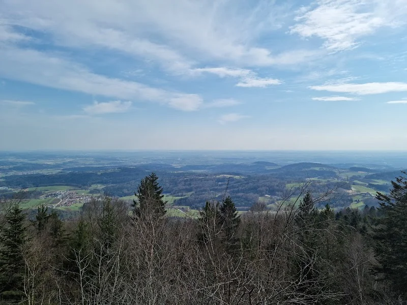
Height is also a central theme around Ruselabsatz. The official tour description states that Ruselabsatz is at 855 meters; in the immediate vicinity are other notable points such as Geßingerstein at 874 meters and Königstein at 850 meters. This arrangement makes the area so interesting for panorama search queries, as mountain pass, high forest, and viewpoint alternate over a short distance. The view, according to the official description, extends over the Lallinger Winkel, the foothills, and the Danube plain, and in good visibility even further towards the Alps. The district additionally emphasizes that Geßingerstein, as a natural monument from the Ice Age, offers a view into the vastness of the Danube plain up to the Alps, while Königstein provides a view into the Lallinger Winkel. For visitors wanting to take photos, this is a strong motif profile: open distant views, forest contrasts, winter moods, fog layers over the Danube Valley, and clear air after föhn conditions. From an SEO perspective, the combination of ruselabsatz photos, ruselabsatz camera, and ruselabsatz height is therefore also sensible, as the location not only functions as a hiking spot but also evokes visual longing. Those visiting Ruselabsatz are usually looking for not just a path but an image: the moment when the Danube plain, the forest, and the sky merge into a single view. ([deggendorf.travel](https://deggendorf.travel/freizeit/wandern/zielwanderweg-ruselabsatz?utm_source=openai))
The attractiveness of this height lies not only in numbers but in the interplay of space and distance. Up at the pass, the landscape appears more open, the sky wider, and the transition to the Bavarian Forest more immediate. This also explains why Ruselabsatz is often perceived as a gateway to the mountains, even though it remains easily accessible. The place creates a rare connection between elevation and logistical simplicity: you get there quickly, stand in the panorama swiftly, and can immediately decide whether the day should be more sporty, tranquil, or wintry. For photography fans, this is a plus, as light and landscape show themselves differently in every season. In spring and summer, the contrast of forest and expanse dominates, in autumn the fog over the valleys, and in winter the snow and light edge of the mountain pass. This is precisely why Ruselabsatz transcends pure tour logic: it is a location where one does not just traverse nature but consciously observes it. This is the real reason why terms like ruselabsatz photos and ruselabsatz height work so well. ([deggendorf.travel](https://deggendorf.travel/freizeit/wandern/zielwanderweg-ruselabsatz?utm_source=openai))
Weather, Webcam, and Snow Conditions Before the Tour
At an elevation site like Ruselabsatz, the weather plays a special role. The official tourism presentation of the region operates its own Rusel webcam and asks there for the current weather conditions at the Rusel functional house; additionally, webcam portals show several cameras in the vicinity of the mountain pass. For planning, this is more than just a nice extra, as in this elevation, fog, wind, snow, and sunshine can change within a short time. Especially in winter, checking the camera and weather conditions is therefore sensible before heading to the ski trail, winter hiking path, or toboggan run. The official winter sites explicitly recommend checking the weather conditions before starting the tour, and the ski trail and winter maps link this recommendation with the starting points around Ruselhaus and Ruselabsatz. So, those searching for ruselabsatz weather or ruselabsatz camera typically do not want abstract climate information but a concrete decision-making aid: is the trip worth it today, is the snow condition stable, and is the visibility good enough for a panoramic experience? Ruselabsatz, with its webcam and winter tourism hints, is excellently prepared for this. Thus, a simple mountain pass becomes a place where one cleverly combines excursion, movement, and current conditions. ([deggendorf.travel](https://deggendorf.travel/rusel-webcam?utm_source=openai))
For visitors, this weather orientation is particularly valuable as it saves time and makes the tour more planable. If the webcam shows good visibility, there is much to be said for a hike to Geßingerstein or a longer round towards Landshuter Haus. If there is snow, the focus shifts to the ski trail, winter path, or a quiet walk in the area of the hiking center. This flexibility is a significant part of the charm at Ruselabsatz: the place does not react to weather with stagnation but with suitable alternatives. This is precisely why it is worth thinking about the excursion not only in terms of the route but also in terms of the conditions. Those using the webcam get a quick visual assessment and can make a targeted decision for hiking shoes, cross-country skis, or warm winter gear. Thus, Ruselabsatz meets several expectations at once: it is an excursion destination, starting point, viewpoint, and weather indicator. This is practical for locals as well as for guests who want to experience Deggendorf and the Bavarian Forest in one day. ([deggendorf.travel](https://deggendorf.travel/rusel-webcam?utm_source=openai))
Sources:
Show moreShow less
Ruselabsatz | Hiking & Ski Trails
The Ruselabsatz is a mountain pass and also a functional excursion destination on the edge of the Bavarian Forest near Deggendorf. Official tourism sites describe the area as the starting point of the hiking center Rusel-Oberbreitenau; at the Ruselhaus, there is current information and maps, and summer and winter tours start from the parking lot at Ruselabsatz. Those who arrive here find no classic event location, but rather a landscape and movement space: hiking trails, winter hiking paths, cross-country skiing, viewpoints, mountain biking routes, and places to eat are closely situated together. This is exactly what makes Ruselabsatz so attractive for searches related to hiking, ski trails, parking, weather, and snow. The location above Deggendorf immediately gives the feeling of transitioning from the Danube plain into the forest and up into the heights. Even in the first few meters, it becomes clear why the place is interesting for day visitors, families, athletes, and those seeking peace. ([deggendorf.travel](https://deggendorf.travel/freizeit/wandern/zielwanderweg-ruselabsatz?utm_source=openai))
Hiking and Circular Trail at Ruselabsatz
The most important theme at Ruselabsatz is hiking. Official sites name the location as the starting point for the destination hiking trail Ruselabsatz; the tour is marked as circular route 4, about 5.3 kilometers long, takes approximately 2.5 hours, and overcomes around 312 meters of elevation. The path initially leads from the parking lot of the cross-country skiing and hiking center over forest roads as well as forest and meadow paths, crosses a feeder to the Goldsteig and the local GEHsundheitsweg, thus connecting several well-known routes. A particularly rewarding detour is to the Geßingerstein, from which a wide view opens over the Lallinger Winkel, the foothills, and the Danube plain; in good visibility, the view even extends to the Alps, and in föhn conditions, one can officially recognize the Hohensalzburg Fortress in the distance. Those who prefer a shorter route can use Ruselabsatz as a starting point for the surrounding circular and destination paths or as an entry into the hiking center Rusel-Oberbreitenau, which, according to the district, offers hiking fun on over 400 kilometers of trails. The mix of marked infrastructure, nature experience, and easily recognizable destinations explains why search queries like ruselabsatz hiking and ruselabsatz circular trail are among the strongest terms. ([deggendorf.travel](https://deggendorf.travel/freizeit/wandern/zielwanderweg-ruselabsatz?utm_source=openai))
In practice, the clarity of the paths at Ruselabsatz is a significant advantage. The region around Rusel, Hausstein, and Oberbreitenau is not only scenically appealing but also logically developed: path markings, feeders, and destination hiking trails complement each other, allowing you to plan both a leisurely round and a longer tour. The destination hiking trail Ruselabsatz is well-suited for those looking for a manageable yet not boring route. The combination of forest road, woodland path, and more open sections keeps the tour varied without becoming confusing. This is also a plus for families, as there are clear orientation points along the way, and the path can be easily thought out in stages. Those who want to seriously explore the region should also take time for the surroundings: Ruselabsatz is not only a starting point but part of a connected network of hiking destinations, viewpoints, and places to eat. This is precisely why terms like ruselabsatz deggendorf and ruselabsatz elevation often appear in searches, as the location itself is already an essential part of the experience. ([deggendorf.travel](https://deggendorf.travel/freizeit/wandern/zielwanderweg-ruselabsatz?utm_source=openai))
Parking, Access, and Costs at Ruselabsatz
For access and parking, Ruselabsatz is also well-equipped, even though it is not a parking lot in the strict sense, but an organized starting point in the hiking area. The district names the hiking parking lots at Ruselhaus on Ruselbergstraße or St 2135, at Ruselabsatz, in Rohrmünz, and in Unterbreitenau as ideal starting points for tours on the Rusel. It is important for on-site use that the Ruselhaus at the parking lot serves as an information point, thus acting not only as an orientation aid but also as a practical meeting point for maps, routes, and weather questions. In winter, the parking situation shifts somewhat: for the toboggan run on the side of the former mountain hotel Rusel, the parking lot there is available on weekends, while on other days, parking can be done at Ruselabsatz, from where the winter hiking path along the road is used; the parking lot at the golf course opposite is closed. This is valuable for hikers and winter guests because it allows for flexible planning of the journey. An official parking fee is not listed on the mentioned sites, so visitors are best advised to pay attention to the current signage and information on-site. Here, too, the search demand is logical: those entering ruselabsatz parking or ruselabsatz parking costs are usually not looking for extensive infrastructure, but a clear, reliable answer regarding practical accessibility. ([landkreis-deggendorf.de](https://www.landkreis-deggendorf.de/tourismus-kultur/freizeit-aktiv/wandern/wandern-auf-der-rusel/?utm_source=openai))
Additionally, Ruselabsatz is an important meeting point for sporting formats and guided tours. The district uses the south-side parking lot as a meeting point for hikes around the Königsstein, and at the Heimat Trails Trophy, Ruselabsatz has repeatedly been described as a prominent start and finish area. This shows that the place works not only for spontaneous day-trippers but also for organized leisure offerings. Those arriving by car benefit from the compact development: from the parking lot, it is only a few steps to the transition into the paths of the hiking center, to the entrances to the ski trails, or to the starting points for winter and snowshoe tours. Especially in winter, this proximity to the start is crucial, as one does not have to undertake long approaches first. Thus, a parking lot becomes a meaningful logistical hub for day trips. So, those searching for a combination of ruselabsatz deggendorf, ruselabsatz parking, and ruselabsatz weather are essentially planning an excursion that arrives comfortably and quickly leads into nature. ([landkreis-deggendorf.de](https://www.landkreis-deggendorf.de/aktuelles/aus-dem-landkreis/mit-der-rangerin-zum-koenigsstein/?utm_source=openai))
Cross-Country Skiing, Ski Trails, and Snow in the Rusel Area
In winter, Ruselabsatz becomes the entry point to one of the most famous cross-country skiing areas in the region. The official ski trail information names Deggendorf or Ruselabsatz as the main starting point of the Rusel ski trail; the route runs 13.7 kilometers from Ruselabsatz initially towards Hölzerne Hand and further to the Landshuter Haus. Additionally, the elevation ski trail Rusel-Oberbreitenau describes the area at about 1,020 to 1,070 meters above sea level as particularly snow-secure, which explains the appeal of the area for cross-country skiers, snowshoe hikers, and winter walkers. The maps and ski trail plans also feature the Ruselhaus area with restrooms and changing rooms, increasing the practical benefit for winter guests. Those who embark on the ski trail experience the typical combination of quiet forest passages, open winter heights, and good connections with other routes around Oberbreitenau. It is important that the official winter sites repeatedly emphasize checking the weather conditions before starting the tour, as snow conditions, track quality, and wind can change quickly at this elevation. This is precisely why terms like ruselabsatz ski trail, ruselabsatz cross-country skiing, ruselabsatz snow, and ruselabsatz elevation are so closely connected: it is not just about a point on the map, but about the functional start to a complete winter area. ([module.tourinfra.com](https://module.tourinfra.com/arberland/details.php?id=148212&utm_source=openai))
Practically speaking, Ruselabsatz is particularly attractive for cross-country skiing because the paths do not have to be laboriously searched for. The region has neatly networked its ski trail, elevation ski trail, and winter hiking paths, allowing both beginners and experienced winter sports enthusiasts to orient themselves. The route descriptions make it clear that not only a single circular route is offered here, but an area where several winter movement forms come together. This is an ideal advantage for guests from Deggendorf and the Danube Valley: one can quickly drive to a snow-secure elevation and start the day directly on the trail. Families also benefit from the fact that the winter offerings around Ruselabsatz can be well combined. Those who only want a short round can stay on the well-marked sections; those seeking more sporting challenges can combine ski trails and elevation paths with longer ascents. Thus, the search query ruselabsatz cross-country skiing becomes a complete winter plan that connects movement, views, and nature experiences. ([module.tourinfra.com](https://module.tourinfra.com/arberland/details.php?id=148212&utm_source=openai))
Landshuter Haus and Dreitannenriegel as Tour Destinations
Among the most popular destinations around Ruselabsatz is the Landshuter Haus. The district describes the mountain house as nestled between Breitenauriegel, Einödriegel, and Geißkopf; it is a popular destination for hikers and mountain bikers and in winter also for cross-country skiers and snowshoe hikers. For this reason, it can be excellently integrated into longer tours from Ruselabsatz, whether as a stop, turning point, or stage on a sporty round through the Rusel area. The official maps of the region also show connections leading over Hölzerne Hand and Breinauriegel to the Landshuter Haus, as well as winter variants connecting to the elevation ski trail. Those additionally searching for Dreitannenriegel will find on the tourist hiking pages the note that the area around Rusel and Hausstein extends up to Dreitannenriegel and that Dreitannenriegel is considered the local mountain of Deggendorf. The winter hiking flyer even lists a destination hiking trail from Ruselabsatz to Dreitannenriegel. This is relevant for SEO and real planning alike, as many search queries ultimately lead to a concrete tour decision: where can I continue from here, where is a break worthwhile, and which destination is the most impressive? The answer often is: Landshuter Haus, Dreitannenriegel, or a combination of both. Ruselabsatz is thus not only a starting point but a hub for several of the most well-known local mountains around Deggendorf. ([landkreis-deggendorf.de](https://www.landkreis-deggendorf.de/tourismus-kultur/gastronomie/gastronomie-im-wanderzentrum-rusel/landshuter-haus/?utm_source=openai))
The connection between tour and refreshment is particularly strong. The Landshuter Haus is not just a name on the map, but a destination that enriches hikes in content. Those who arrive there have usually already covered part of the elevation and are now seeking a break, orientation, and the next section. This makes the entire Rusel region very user-friendly for day visitors, as the paths do not remain isolated but connect to a gastronomic and scenic structure. Dreitannenriegel also has a clear role in this context: as the local mountain of Deggendorf, it represents a classic summit experience with panorama and its own character. Search queries like ruselabsatz landshuter haus and ruselabsatz dreitannenriegel reflect this behavior precisely. People want to know not only that there is a hike but where they can meaningfully extend it. Ruselabsatz provides a very good answer to this, as it bundles several destinations in one place, allowing for both spontaneous and ambitious tours. ([landkreis-deggendorf.de](https://www.landkreis-deggendorf.de/tourismus-kultur/gastronomie/gastronomie-im-wanderzentrum-rusel/landshuter-haus/?utm_source=openai))
Height, Panorama, and Photos around Deggendorf
Height is also a central theme around Ruselabsatz. The official tour description states that Ruselabsatz is at 855 meters; in the immediate vicinity are other notable points such as Geßingerstein at 874 meters and Königstein at 850 meters. This arrangement makes the area so interesting for panorama search queries, as mountain pass, high forest, and viewpoint alternate over a short distance. The view, according to the official description, extends over the Lallinger Winkel, the foothills, and the Danube plain, and in good visibility even further towards the Alps. The district additionally emphasizes that Geßingerstein, as a natural monument from the Ice Age, offers a view into the vastness of the Danube plain up to the Alps, while Königstein provides a view into the Lallinger Winkel. For visitors wanting to take photos, this is a strong motif profile: open distant views, forest contrasts, winter moods, fog layers over the Danube Valley, and clear air after föhn conditions. From an SEO perspective, the combination of ruselabsatz photos, ruselabsatz camera, and ruselabsatz height is therefore also sensible, as the location not only functions as a hiking spot but also evokes visual longing. Those visiting Ruselabsatz are usually looking for not just a path but an image: the moment when the Danube plain, the forest, and the sky merge into a single view. ([deggendorf.travel](https://deggendorf.travel/freizeit/wandern/zielwanderweg-ruselabsatz?utm_source=openai))
The attractiveness of this height lies not only in numbers but in the interplay of space and distance. Up at the pass, the landscape appears more open, the sky wider, and the transition to the Bavarian Forest more immediate. This also explains why Ruselabsatz is often perceived as a gateway to the mountains, even though it remains easily accessible. The place creates a rare connection between elevation and logistical simplicity: you get there quickly, stand in the panorama swiftly, and can immediately decide whether the day should be more sporty, tranquil, or wintry. For photography fans, this is a plus, as light and landscape show themselves differently in every season. In spring and summer, the contrast of forest and expanse dominates, in autumn the fog over the valleys, and in winter the snow and light edge of the mountain pass. This is precisely why Ruselabsatz transcends pure tour logic: it is a location where one does not just traverse nature but consciously observes it. This is the real reason why terms like ruselabsatz photos and ruselabsatz height work so well. ([deggendorf.travel](https://deggendorf.travel/freizeit/wandern/zielwanderweg-ruselabsatz?utm_source=openai))
Weather, Webcam, and Snow Conditions Before the Tour
At an elevation site like Ruselabsatz, the weather plays a special role. The official tourism presentation of the region operates its own Rusel webcam and asks there for the current weather conditions at the Rusel functional house; additionally, webcam portals show several cameras in the vicinity of the mountain pass. For planning, this is more than just a nice extra, as in this elevation, fog, wind, snow, and sunshine can change within a short time. Especially in winter, checking the camera and weather conditions is therefore sensible before heading to the ski trail, winter hiking path, or toboggan run. The official winter sites explicitly recommend checking the weather conditions before starting the tour, and the ski trail and winter maps link this recommendation with the starting points around Ruselhaus and Ruselabsatz. So, those searching for ruselabsatz weather or ruselabsatz camera typically do not want abstract climate information but a concrete decision-making aid: is the trip worth it today, is the snow condition stable, and is the visibility good enough for a panoramic experience? Ruselabsatz, with its webcam and winter tourism hints, is excellently prepared for this. Thus, a simple mountain pass becomes a place where one cleverly combines excursion, movement, and current conditions. ([deggendorf.travel](https://deggendorf.travel/rusel-webcam?utm_source=openai))
For visitors, this weather orientation is particularly valuable as it saves time and makes the tour more planable. If the webcam shows good visibility, there is much to be said for a hike to Geßingerstein or a longer round towards Landshuter Haus. If there is snow, the focus shifts to the ski trail, winter path, or a quiet walk in the area of the hiking center. This flexibility is a significant part of the charm at Ruselabsatz: the place does not react to weather with stagnation but with suitable alternatives. This is precisely why it is worth thinking about the excursion not only in terms of the route but also in terms of the conditions. Those using the webcam get a quick visual assessment and can make a targeted decision for hiking shoes, cross-country skis, or warm winter gear. Thus, Ruselabsatz meets several expectations at once: it is an excursion destination, starting point, viewpoint, and weather indicator. This is practical for locals as well as for guests who want to experience Deggendorf and the Bavarian Forest in one day. ([deggendorf.travel](https://deggendorf.travel/rusel-webcam?utm_source=openai))
Sources:
Frequently Asked Questions
Reviews
No reviews found