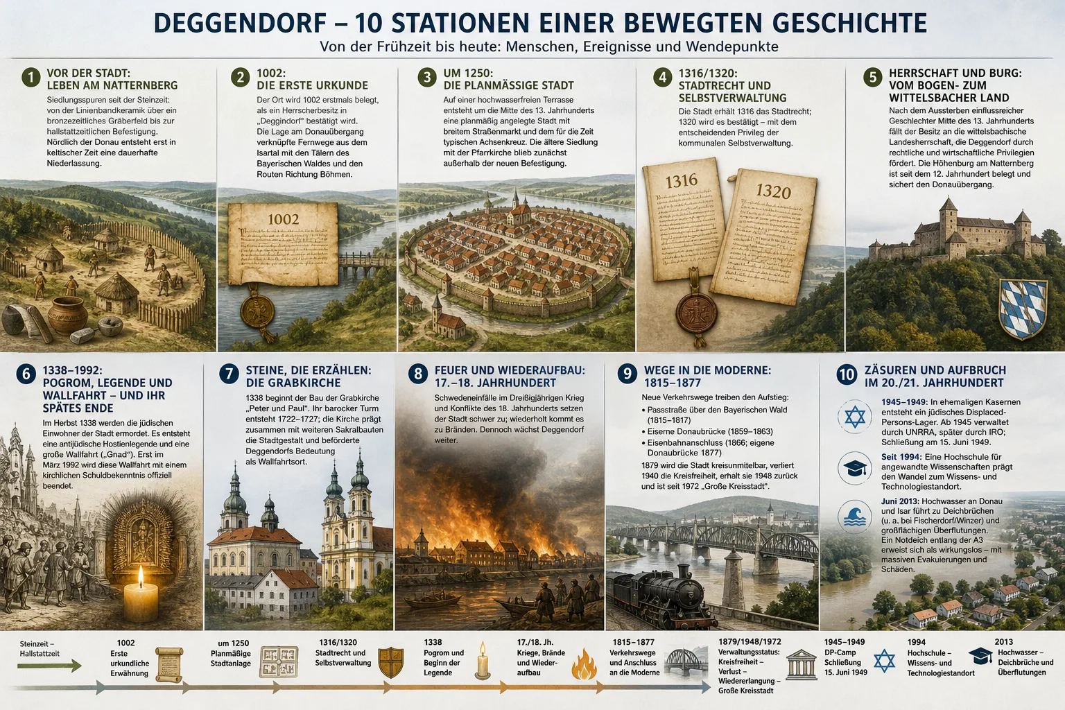
The History of Deggendorf in 10 Stations
Experience Deggendorf in 10 Stations: A Walk into the Future (Plan for Your Next Visit)
This post is a practical plan for a future city walk in Deggendorf: ten thematic stations that you can tackle during your next stay (alone, as a group, or as a school class) in chronological order. The focus is on places and sightlines – supplemented by guiding questions that you can reflect on at each location.
Station 1: Kickoff at Natternberg (Panoramic View & "Deep Time")
Start your next visit to Deggendorf with a highlight: Plan a climb (or a drive, depending on your route) to the Natternberg area to read the city, the Danube, and the valley spaces as a "3D map".
- What to look for: Landforms, sightlines, transitions between valley, river area, and elevations.
- Guiding questions on site: Which places seem like natural nodes? Where would you expect paths, crossings, or protected locations?
- Further exploration afterwards: If you wish, you can enrich this station with information from archaeology and monument preservation (see sources).
Station 2: Danube Crossing & Crossroads – Why Places Grow
For the second station, choose a point where you can clearly see the Danube crossing and the access to the city center. The goal is to experience the logic of accessibility on your next walk.
- What to look for: Bridge connections, riverside paths, transitions between traffic and urban spaces.
- Guiding questions: Which movements (on foot, by bike, car, public transport) are preferred here? Where do bottlenecks arise – and where are places to linger?
- Optional: Note how long it takes you from the riverbank to the old town; this "time scale" will help you later to understand urban development spatially.
Station 3: Reading the Old Town Grid – Market, Axes, Orientation
Next, consciously enter the old town area and try to read the urban structure like a map. You will be less "checking off sights" and more recognizing structures.
- What to look for: Straight/bundled streets, intersections as orientation points, square widths, viewing directions.
- Guiding questions: Where does the urban space feel "planned"? Where do paths seem organically grown?
- Tip: Take two photos from the same axis in opposite directions. Later you can compare how visual guidance works in urban space.
Station 4: Town Hall Area – City as Self-Organization
Plan a station at the town hall area (or a central administrative/market space) to reflect on the city as a set of rules, negotiation, and participation.
- What to look for: Building language (representative/purposeful), information areas, path relationships to commerce and public spaces.
- Guiding questions: What makes a place "public"? Where is order visible (signage, seating, accessibility, usage rules)?
- Further exploration: If you are interested in municipal development, you will find suitable classifications in city chronicles or museum offerings after your visit (see sources).
Station 5: Castle/Hill Locations & "Control" in the Cityscape
For the fifth station, choose a point where the relationship between elevation, river area, and city is clearly visible. On your next tour, you will trace the role of protection, overview, and access in the space here.
- What to look for: Sightlines to crossings, bottlenecks, bridges, access roads; also places that have an "overlooking" effect.
- Guiding questions: Which areas are easy to overlook – and which are not? Where would you expect administration or control for purely spatial reasons?
- Note: Pay attention to information boards on site; they help to clearly separate observation and source knowledge.
Station 6: Culture of Remembrance – Dealing with Difficult Chapters
Plan a station explicitly dedicated to the culture of remembrance: a memorial, a church, a square with an explanatory plaque, or a museum context. The goal is to consciously perceive during your future visit how a city remembers difficult topics.
- What to look for: Language of the plaques, design (quiet/confrontational), choice of location (central/off to the side), references to educational offerings.
- Guiding questions: Which perspectives become visible? What remains open? Which sources are mentioned?
- Sensitive framework: If you are planning the walk as a group, allow time for discussion and classification in this section.
Note on reliability: For in-depth historical classification, you will preferably use scientific presentations, museums, and official documentation (see sources).
Station 7: Church of the Holy Sepulchre – Architecture as a Memory Store
The seventh station offers a striking sacred building (e.g., the Church of the Holy Sepulchre). On your next visit, you will view the church not just as a "beautiful building" but as a multi-layered memory store: use, alterations, symbolism, impact on the cityscape.
- What to look for: Architectural style elements, tower and roof shapes, location in the urban space, indications of restorations.
- Guiding questions: What does the building signal outwardly? What role do acoustics, spatial effect, and path guidance play?
- Optional: Check future concert or guided tour dates in advance; this way you can combine architecture with user experience.
Station 8: Fire Protection, Crises, Reconstruction – Recognizing Layers
Choose a street or neighborhood where different building periods can be read. On your upcoming walk, the aim is to recognize city layers without dating too quickly.
- What to look for: Rhythm of facades, roof shapes, material changes, unevenness in the street space, "breaks" in the building line.
- Guiding questions: Where does something seem renewed? Where more preserved? What clues do plaques, monument lists, or museum offerings provide?
- Practice: Draw a mini-sketch (30 seconds is enough): window axes and roofline are sufficient to make differences visible.
Station 9: Bridges, Rail, Mobility – Experiencing Modern Connectivity
For station nine, plan a consciously "modern" mobility perspective: station area, bridge spaces, or junctions between the old town and newer neighborhoods. On your next visit, you will perceive Deggendorf as a connected system.
- What to look for: Transfers, signage, bicycle parking, interfaces between pedestrian and vehicular traffic.
- Guiding questions: Which routes are intuitive? Where do barriers arise? How do mobility offerings change the quality of stay?
- Optional: If you are traveling with family or a group, consciously test "barrier-free" routes (fewer steps, good crossings).
Station 10: Reading the 20th/21st Century on Site – Learning, Migration, Risk
The last station of your future tour brings together contemporary topics that you can observe directly in the cityscape: educational sites, memorial/documentation offerings on migration experiences, and the handling of natural hazards in the river area.
- What to look for: Campus/educational infrastructure, international signs (languages, offerings), flood marks/protection systems (if indicated), information from authorities.
- Guiding questions: Where does "city of the future" show itself (learning, innovation)? Where does "city on the river" show itself (protection, adaptation, risk communication)?
- Safety framework: If you are traveling during high water levels in the future, follow official warnings and closures.
Note (Safety): This post does not replace official hazard information. For current information on weather, water levels, closures, and protective measures, you will use official sources (see sources).
Practical Implementation (for Your Next Appointment)
Recommended Duration
For all ten stations, you will typically plan 2.5 to 4 hours depending on your pace and breaks. If you want to walk over two days, divide the tour sensibly into "Old Town & Sacred Spaces" and "River Area & Mobility".
Route as Principle (instead of Rigid Directions)
So that the plan works without incorrect details, your future route is best guided by this principle: Elevated View → River Area → Old Town Structure → Remembrance/Architecture → Mobility Nodes → Contemporary Places. This way you keep the dramaturgy, even if you spontaneously shorten on site.
Accessibility
If you plan for accessibility, you will either skip sections with steep inclines (e.g., elevations) or replace them with a viewpoint that is accessible without steps. In the old town, you will also consider crossings, curbs, and cobblestones.
For School Classes & Groups
- Preparation: Set 3–5 guiding questions in advance (e.g., "What makes a place a center?").
- On site: Work with short tasks (photo axis, sketch, quote from info board).
- Follow-up: Use the source list below to turn observations into verifiable knowledge.
Sources & Further Links
- City of Deggendorf (official website) — Contact point for culture, city life, facilities, and current information (accessed 2026-10-21)
- Bavarian State Office for Monument Preservation (BLfD) — Background on monument preservation, monument lists, and classification methodology (accessed 2026-10-21)
- House of Bavarian History — Contexts on Bavarian state history for follow-up (accessed 2026-10-21)
- Deggendorf Institute of Technology — Information on campus, study programs, and events as a contemporary reference (accessed 2026-10-21)
- Bavarian Flood Information Service (HND) — Official water level, situation, and warning information for future visits to the river area (accessed 2026-10-21)
- Federal Agency for Civic Education (bpb) — Dossiers and background texts for classifying culture of remembrance and contemporary history (accessed 2026-10-21)